|
<< Click to Display Table of Contents >> Ground Profile Import |
  
|
|
<< Click to Display Table of Contents >> Ground Profile Import |
|
To access this option, Belt Analyst needs to be in Advanced User mode in the Profile Tab.
Click here to watch a video on how to import a ground profile using a DXF file.
Click here to watch a video on how to import a ground profile using a KML file.
While in the Profile page, select the Import/Export > Export tab in ribbon menu. Then click the Import Ground Profile found there to bring up the following window.
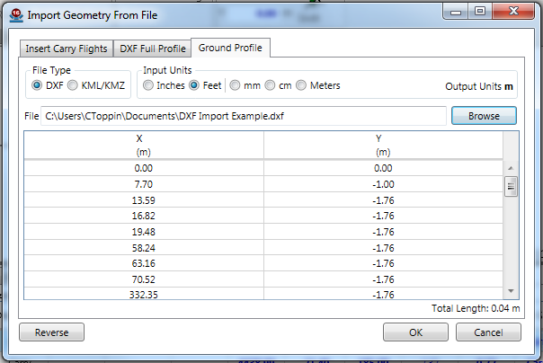
To import from a DXF file, select DXF as the File Type, choose the units the DXF file was drawn in from the Input Units section, and then browse for the DXF file. Once you've selected the file, you'll be asked to select from all layers with one polyline on them. Once selected, the file will automatically begin importing.
To import from a KML/KMZ file created with Google Earth, select KML/KMZ as the File Type, and then browse for the KML/KMZ file. Once selected it will automatically find the first LineString in the file and import it using the distance between each point as the X, and the Google elevation records for the lat/long point as the Y.
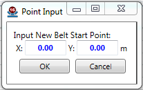
Once the data has been gathered, the reverse button can be used to flip the points if needed (it'll ask for a point to "mirror" from), or you can click "Ok" to add the profile to the drawing. Once you select "Ok", you'll be given the option to move the start of conveyor to a new location. The location shown in this window is always where your belt is currently located.
The ground profile will show as a light orange line behind the belt in the advanced profile view.